- [en]
 Spatial Process Tool
[en]  Spatial Process Tool
[en] Use the Spatial Process tool to perform high-level spatial object editing from a simple, single tool. You can combine multiple objects or cut the spatial objects of the input table.
[en] For information about what types of objects can be processed and their corresponding results, refer to Spatial Process Results.
[en] Configure the Tool
[en] The input file must have 2 different spatial object fields associated with each data record. Each action results in the creation of a third spatial polygon object.
[en] Select the 1st Spatial Field and the 2nd Spatial Field.
[en] Select the Action to perform.
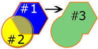
[en] Combine Objects: Creates a third object by combining both spatial field objects into one object.
[en] Cut 1st from 2nd: Creates a third object by removing the first object where the second object overlaps the first. The first object is only cut when it shares the same record as the second object.

[en] Cut 2nd from First: Creates a third object by removing the second object where the first object overlaps the second. The second object is only cut when it shares the same record as the first object.

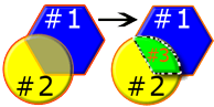
[en] Create Intersection Object: Creates a third object made up of the area where the first and second objects occupy the same area.
[en] Create Inverse Intersection Object: Creates a third object made up of the entire area that the first and second objects occupy, dropping the area where they intersect.

[en] Don't Output Empty Objects: Check this box so that empty objects are not included in the output.