- [en]
 Buffer Tool
[en]  Buffer Tool
[en] One Tool Example
[en] Buffer has a One Tool Example. Visit Sample Workflows to learn how to access this and many other examples directly in Alteryx Designer.
[en] Use Buffer to take any polygon or polyline spatial object and expand or contract its extent by a user-specified value.
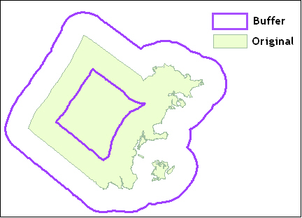
[en] This image shows a positive buffer of 1 mile and a negative buffer of -1 mile.
[en] Configure the Tool
[en] Specify the SpatialField that contains the spatial object to be buffered.
[en] IncludeinOutput: The user can choose whether or not to include the original spatial object in the output stream. The default is unchecked so the object is not included.
[en] Generalize to 1% of Buffer size: Selected by default. This optimizes speed by cutting down the number of nodes in the buffered object.
[en] Set the BufferSize parameters.
[en] SpecificValue: Input a numerical value and all records are buffered to this size
[en] FromField: Select a numerical field in the connection stream and each record is buffered by the value of that field.
[en] Units: Choose to buffer the object in units of Miles or Kilometers.